The Stonycreek Watershed at the Time of the Scalp Level Artists
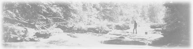
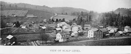
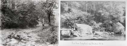
George Hetzel, who visited the hamlet of Scalp Level in 1866 during a fishing vacation, was so taken with the area's splendid scenery that he encouraged fellow Pittsburgh artists to join him there in subsequent summers, sketching and painting landscape scenes. What would these painters—who collectively became known as the Scalp Level School—have seen as they travelled on foot in the vicinity of Scalp Level, around the lower (northern) section of the Stonycreek watershed?*

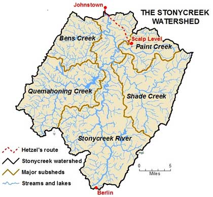
(*Note: In the discussion that follows, the terms "Stonycreek watershed" and "the Stonycreek" are used broadly, to refer collectively to all of the watersheds illustrated in Figure 1, except when explicit reference is made to the watershed of the Stonycreek River.)


Figure 1. George Hetzel and other Pittsburgh artists summered in Scalp Level, painting landscape scenes around Paint Creek, Shade Creek and the lower Stonycreek River.
Scalp Level was a tiny settlement about a ten mile overland journey from Johnstown. Map credit: Mary Lavine

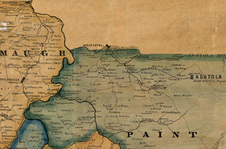
Edwin Walker's 1860 Map of Somerset County and other period documents provide some clues about what the painters might have seen. Beyond Johnstown, town-oriented activities were limited: a couple of blacksmiths, a hotel, store and wagon shop in "Jenner X Road" (today's Jenners Crossroads), and a shoe shop in Jennerville (now Jennerstown).


Figure 2. Segment of the Walker Map of Somerset County, PA, 1860, showing the area around Scalp Level (misnamed Scelp Level on this map).Beginning in the late 1860s, Pittsburgh artists summered at Scalp Level to sketch and paint the local landscape. Paint Creek, which appears in many paintings, is shown in the upper right portion of the map, as is the wooden tram road along which lumber was hauled from the lumber mill at Ashtola to Scalp Level. Traces of the tram line are still visible today in Babcock Forest. In addition to Paint Creek, other streams featured by the artists and shown on this map segment include the Stonycreek River and its major tributaries, Shade Creek and Bens Creek. The distance from Scalp Level to Ashtola is about five linear miles, and the same is true from Scalp Level to Benscreek Furnace. Given that actual walking distances overland were somewhat greater, this map illustrates the probable limits of the painters' hikes most days, within Somerset County. The complete map can be viewed online by clicking here. It may also be viewed at the Historical and Genealogical Society of Somerset County, in Somerset, Pennsylvania.

Source: Map of Somerset County, Pennsylvania, 1860, published by A. Pomeroy, 320 Chestnut Street, Philadelphia. Map courtesy of the Pennsylvania State Archives, MG-11 Map Collection, #124 Map of Somerset County, sections 124-2 and 124-3.


Subsistence-oriented farms dominated the local economy, surrounded by virgin forests and abundant, clear streams. Benscreek Furnace, five miles from Scalp Level, had produced pig iron, using local iron ore, limestone, and charcoal cooked in the forest, but the operation was almost certainly closed by 1860. In nearby Ashtola, two sawmills supported a modest logging industry based on the watershed's hemlock, white pine and mixed hardwood forests; these mills are mentioned in subsequent county reports during the 1880s. Around Scalp Level, as was true elsewhere in the Stonycreek watershed, most people earned a living by farming.


Figure 3. The lumber mill at Ashtola was a significant rural industrial site in the 1860s and beyond. Its importance is demonstrated by its appearance in an illustration on the border of the Walker Map of 1860.

Source: Map of Somerset County, Pennsylvania, 1860, published by A. Pomeroy, 320 Chestnut Street, Philadelphia. Map courtesy of the Pennsylvania State Archives, MG-11 Map Collection, #124 Map of Somerset County, Section 124-3.


Figure 4. Scalp Level circa 1894, where George Hetzel and other Pittsburgh artists resided during their excursions to the Stonycreek area. In the late nineteenth century, Scalp Level was still an unincorporated village within Richland Township. About half of its three dozen homes are shown in this photograph. Little Paint Creek, which flows through the village, merges into Paint Creek at Scalp Level. Note the surrounding farmland and woods, evidence of the settlement's rural surroundings.

Source: "View of Scalp Level," Art Work of Cambria County, 1894. Photo courtesy of Archives, Johnstown Area Heritage Association, Johnstown, Pennsylvania.

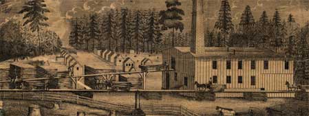
Elsewhere in the watershed, but probably beyond the wanderings of the Scalp Level artists, the 1860 map lists some rural industries, including six water powered saw mills, four tanneries, a grist mill, a woolen manufacturer, a potter, and two iron furnaces (both had closed during the 1850s), along with more limestone and iron deposits. The map notes more than a dozen tiny coal mines or coal banks; at that time these likely produced house coal, most likely during the winter—the farmer's slack season. The Second Geological Survey of Pennsylvania of 1875 (published 1877) surveyed, mapped and extensively described the watershed's rich bituminous coal deposits, which within four decades would become the focal point of the area's economic base. At the time of the Survey, however, there was hardly more than a handful of active coal mines in the watershed. Agriculture was the dominant economic activity.

In short, what we see in the Scalp Level paintings is confirmed by other sources: a thinly settled, overwhelming forested, rural landscape with many picturesque streams, where the human influence was evident mostly in the form of modest, isolated farms.


Figure 5. Paint Creek in the late nineteenth century. In the photograph on the left, artist George Hetzel has captured a segment of Paint Creek, likely upstream from the falls. Today, however, as this portion of Paint Creek flows through Windber, it is confined to a concrete channel. On the right, Johnstown businessman Powell Stackhouse's 1886 photograph shows another portion of Paint Creek, most likely taken below the falls. Today this segment of the stream likely looks much like it did more than one hundred years ago, except for the red-stained rocks, a consequence of upstream mining activities.

Photograph credits:

George Hetzel [American, b. France, 1826 – 1899]
Scalp Level Autumn along Paint Creek, c. 1895
Gelatin silver print produced from glass plate negative, 4" x 5"
R. K. Mellon Family Foundation Art Acquisition Endowment Fund
Collection of the Southern Alleghenies Museum of Art [96.046.006]

Powell Stackhouse. Paint Creek, Scalp Level—near Johnstown. 7-5-'86.
Photograph courtesy of Archives, Johnstown Area Heritage Association, Johnstown, Pennsylvania.


INTERESTED IN LEARNING MORE?

Edward L. Walker's Map of Somerset County, 1860 shows the location of many farms and other activities—saw mills, tanneries, coal mines and the like. It's great for genealogical research, too, since farms are identified by their owners' names. To view this map, in nine sections, from the Pennsylvania Historical & Museum Commission, State Archives Division website, click here.


Back to Top


Copyright ©2008 Stonycreek Quemahoning Initiative
Stonycreek-Quemahoning Initiative is a 501(c)(3) and a supporting organization of Conemaugh Valley Conservancy
Site Designed by Hurst Media Works, KH2 Design, FisherWorks Consulting and Recharge Web Design