 |
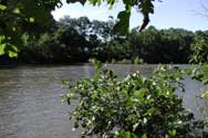
The
Stonycreek River is a classic freestone river
that begins at Pius Spring in Berlin Borough and flows to
the north for 46 miles to the Point in Johnstown. There it
merges with the Little Conemaugh River to form the Conemaugh
River. The Stony's major tributaries include Glades Creek,
Wells Creek, Beaverdam Creek, Quemahoning Creek, Shade
Creek, Paint Creek and Bens Creek. Altogether, the
Stonycreek drains 468 square miles just west of the Eastern
Continental Divide. Its headwaters form at elevations
exceeding 2,900 feet above sea level on the Allegheny Ridge
to the east and Laurel Ridge to the west, while its mouth in
Johnstown is at 1,150 feet.
For more information.
|
 |
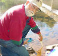
Pollution
of the once-pristine Stonycreek Corridor started around the
turn of the 20th century, when loggers clear-cut hillside
tracts of virgin white pine and hemlock, and coal companies
developed underground mines. The clear-cutting destroyed
ecosystems and encouraged top-soil runoff. Coal operators
created huge waste piles called "boney" that fouled adjacent
streams. When companies closed or abandoned mines, they
flooded them with water. That water became highly acidic,
leached metals such as iron, aluminum and manganese, then
worked its way to the surface. Abandoned-mine drainage (AMD)
killed aquatic life throughout the river system and rendered
much of the Stonycreek River all-but devoid of life for most
of the 20th century.
For more information.
|
 |
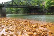
The
Stonycreek's recovery began with significant
changes in mining activity, starting in the 1980s, and
second-growth forests once again filtering the landscape.
But killer AMD discharges still were blocking most aquatic
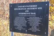
life from the river downstream of Kantner. Coalitions of
local, state and federal groups collaborated effectively to
install passive treatment systems (wetlands) for three
heavily impacted streams, Oven Run, Pokeytown Run and
Quemahoning Creek. The overall result of recent decades of
nature's self-healing, changes in mining practices, and
effective passive treatment is the renewal of life
throughout the Stonycreek, from its headwaters to its
confluence with the Little Conemaugh.
For more information.
|
|