View Larger Map
Directions to Driving Tour Stop #3
Turn left out of the parking area and proceed downhill for 0.6 miles to the Carpenter’s Park boat access area on the other side of the bridge that crosses the Stonycreek River.
|
|
Latitude: 40.2472
Longitude: -78.8933
View Map
Print-friendly version
Driving Tour Stop #2
This hillside property, owned by the City of Johnstown, is a remnant of the days when a trolley line connected the city with the coal-mining community of Windber. The line followed the Stonycreek River from Benscreek through Kelso (Tire Hill) to Carpenter’s Park and the mouth of Paint Creek, then followed Paint Creek to Scalp Level and Windber. Residents would ride the trolley to Carpenter’s Park, where they could picnic, swim, socialize in the dance hall or hike up to Yoder Falls. The trolley line was abandoned following the 1936 Flood.
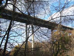
Today, the only public access to Yoder Falls is down a short, well-defined path from this parking area. Halfway down the hill you will hear Yoder Falls. Seeing it from the path depends upon the time of year and foliage. On the lower half of the path, you can see dramatic views of McNally Bridge, which is almost 1,400 feet long and 192 feet high. At the path’s bottom are cut-stone bridge abutments – a historical trace of the trolley line. To reach Yoder Falls, follow the watercourse upstream a couple hundred yards to the falls.
Please be aware that this hike is short but challenging. There is no established path to the falls and footing is difficult among the rocks in the watercourse. Allow 10-20 minutes to reach the falls. Please use caution and proceed at your own risk. The hillside path is steep in spots and features some loose rock. People taking this hike should be in good physical condition and wear proper shoes.
Related Links:
|

