|
 The Lenape Indians named this river “Sinne-hanna” – literally the “stony stream” – which the first Europeans traveling through here interpreted initially as Stony Creek, then sometime later, as the Stonycreek River. Historians believe that the Lenape and Shawnee used this upland plateau primarily as a hunting ground because of the often-harsh character of its winters, but at least one Lenape settlement was mentioned in the earliest histories of this area: Kickenapawling’s Old Town, the site of which now is at the bottom of Quemahoning Lake. “Quemahoning” also was an Indian name that has been translated as “water issuing from a [salt] lick.” The Lenape Indians named this river “Sinne-hanna” – literally the “stony stream” – which the first Europeans traveling through here interpreted initially as Stony Creek, then sometime later, as the Stonycreek River. Historians believe that the Lenape and Shawnee used this upland plateau primarily as a hunting ground because of the often-harsh character of its winters, but at least one Lenape settlement was mentioned in the earliest histories of this area: Kickenapawling’s Old Town, the site of which now is at the bottom of Quemahoning Lake. “Quemahoning” also was an Indian name that has been translated as “water issuing from a [salt] lick.”
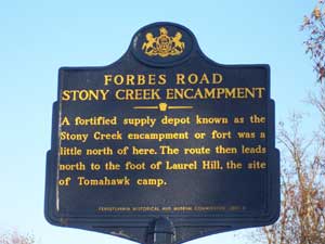
The land, surrounding the headwaters of the Stonycreek River, was known as the “Shades of Death” among the men of Gen. John Forbes’ expedition – indicative of the heavily forested character of the place and its dangers. Forbes’ men constructed at least two and possibly three fortifications within The Stonycreek Corridor during the summer and fall of 1758. Essentially earthen breastworks, the forts were located on Oven Run and near Quemahoning Creek, while a Stonycreek Station was situated on the banks of the river near present-day Kantner. Accounts of the period report that men were killed and scalped in its vicinity.
While the Treaty at Fort Stanwix opened the Stonycreek’s lands for European settlement in 1768, troubles between the settlers and Indians continued here until the 1770s, when negotiations resolved land disputes with Indian nations.
For More History on The Stonycreek in the 18th century click here and go to page 7. (2.4mb)
Forbes Road Driving Tour (258kb)
Related Links:
|